


As an organisation, Mapping for Change are firmly grounded in principles and methodologies of community engagement. Since our origin, our work with grassroots and third sector organisations has aimed to widen citizen participation and involvement in local decisions and actions, by empowering all members of the community.
Our engagement methodology has evolved from many years of experience working in the community and voluntary sector. We use a range of direct and online techniques to reach relevant groups and individuals, and ensure that harder-to-reach perspectives are included.
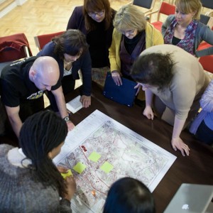
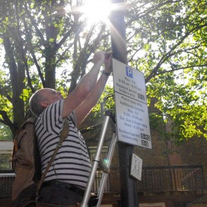
Where appropriate, we utilise a map-based engagement methodology. Maps enable us to communicate with community groups to visualise or analyse their local area in the context of a particular issue, question or concept.
Mapping for Change can provide engagement services to support academic, commercial or public sector projects. We can also provide engagement training, to supply your organisation with all the skills and knowledge required to conduct your own community engagement.
Academic Research
We can provide long or short-term community engagement services for a range of academic research projects. Our engagement services can be used to acquire diverse information from communities, from survey responses to in-depth interviews.
View our Information Sheet for further information.
Engagement Training
Mapping for Change can offer clients a series of tailored engagement workshops. Our flexible approach means we can equip you with specific methodologies and tools appropriate for your organisation.
View our Information Sheet for further information.
-
As an organisation, Mapping for Change are firmly grounded in principles and methodologies of community engagement. Since our origin, our work with grassroots and third sector organisations has aimed to widen citizen participation and involvement in local decisions and actions, by empowering all members of the community.
Our engagement methodology has evolved from many years of experience working in the community and voluntary sector. We use a range of direct and online techniques to reach relevant groups and individuals, and ensure that harder-to-reach perspectives are included.
Where appropriate, we utilise a map-based engagement methodology. Maps enable us to communicate with community groups to visualise or analyse their local area in the context of a particular issue, question or concept.
Mapping for Change can provide engagement services to support academic, commercial or public sector projects. We can also provide engagement training, to supply your organisation with all the skills and knowledge required to conduct your own community engagement.
Academic Research
We can provide long or short-term community engagement services for a range of academic research projects. Our engagement services can be used to acquire diverse information from communities, from survey responses to in-depth interviews.
View our Information Sheet for further information.
Engagement Training
Mapping for Change can offer clients a series of tailored engagement workshops. Our flexible approach means we can equip you with specific methodologies and tools appropriate for your organisation.
View our Information Sheet for further information.
-
-

Evaluating People Zones Leicestershire
Through engaging residents in an Asset-Based Community Development Approach, our research for People Zones Leicestershire generated lasting resources which helped identify opportunities for hyper localised community initiatives. Now, we’re returning to evaluate the program’s impact, aiming to provide concrete evidence of its effectiveness in reducing crime and promoting community well-being.
Coin Street: Assessing Public Sentiment
Leicester Family Hubs
We are excited to help introduce this transformative approach to health and social care to the city of Leicester. Family Hubs will serve as a bridge that bring together various organisations, services, and resources, making it easier for families to access the care and support they need.
We Care for Our Air Redbridge

UP2030: Urban Planning and design ready for 2030
People Zones Leicestershire
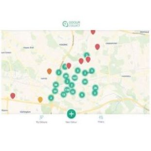
Addressing odour in Southall and Hayes
Science in the City 2
The City of London Corporation and Mapping for Change are teaming up once again to conduct a citizen science project to monitor air quality in the capital city and evaluate the recent changes made in the area. The project will seek to understand the impacts that public participation and citizen science have on environmental issues.
InSPIRES
InSPIRES is a EU-funded project which aims to address the information gap that vulnerable demographics can hold about the impact that air pollution has on their health. Mapping for Change works with a school in London, whereby parents and pupils will have the opportunity to monitor particulate matter and nitrogen dioxide pollution levels in and around their homes.
Kampala NOSES; Network for Odour Sensing Empowerment and Sustainability.
Kampala NOSES is a pilot project that seeks to introduce novel ways with which to monitor and record odour issues across Kampala. All key stakeholders, from policy-makers to public sector administrators, from academics to industries and the community at large are needed to create a longer-term vision of implementing new environmental reporting and governance mechanisms.
CIVACT - Promoting civic engagement among youth through district development
CIVACT is a EU-funded, two-year project which aims to address the lack of civic engagement among hard-to-reach youths in urban areas. The goal is to understand how can we empower young people to become the driving force for change through observing and analysing their neighbourhood’s resources and challenges.

COMENSI - Bridging the gap between adults and civic engagement
An EU project which aims to understand the lack of participation amongst adults, in formal consultations within deprived neighbourhoods. The project aims to understand the reasons for such lack for participation and which tools and strategies could be developed to change it.
Urbex - Engaging Young People Through Urban Exploration
This is a project which used urban exploration as an innovative way to engage young people at risk of social exclusion and encourage their participation in civic issues. Each partner organisation worked in a specific pilot neighbourhood to test and deliver different approaches and applications of urban exploration.
D-NOSES - Tackling Odour Pollution Across Europe
D-NOSES is a three-year EU funded research project which aims to provide a solution to the largely neglected issue of odour pollution, changing the traditional top-down approach for a bottom-up one. The lack of regulation from authorities around odour pollution is mainly due to it being difficult to reliably measure and the potential solutions being costly to implement.
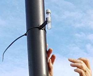
Breathe Clean - Citizen Science in Tower Hamlets
Breathe Clean will be providing Tower Hamlets residents with the materials & training needed to monitor nitrogen dioxide levels around the places that matter to them. Participants will measure the air quality at a number of locations over a period of six months, to get a more granular picture of the situation in the borough. The data from the Breathe Clean project will be made available on Mapping for Change’s community maps webpage.
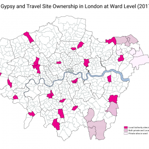
Mapping the Pathway to Equalities
There are around 30,000 Gypsies and Travellers in London. Their culture and traditions have developed through a nomadic way of life over centuries. However, across the country the community face an uncertain future. With some of the poorest social outcomes of any group in Britain the burgeoning cuts to public services will have a disproportionate effect on the community.
Love Lambeth Air
Love Lambeth Air provided local people with the materials and support required to collect measurements for nitrogen dioxide across a number of streets in Lambeth, providing a detailed picture of air quality in their local area.
WeGovNow
WeGovNow is a three year research and innovation project focusing on civic participation in local government. It aims to change the relationship between citizens and local governments, transforming the citizen’s role from customer into partner. This is to be achieved with the development of a single community engagement platform, where citizens can interact with their governments and participate in local decision-making.
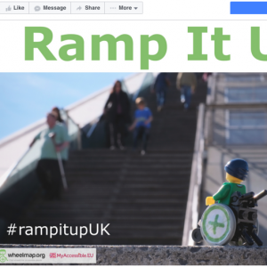
Ramp It Up!
‘Ramp It Up’ was a social media campaign aiming to increase awareness about the barriers people with limited mobility face on a daily basis. We called on communities to help their towns and cities become more wheelchair friendly by encouraging shops, restaurants or any building open to the public to use portable wheelchair ramps if more permanent solutions cannot be made.
Design for Wellbeing
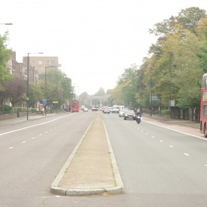
Design for Wellbeing is a multidisciplinary research project funded by the Economic and Social Research Council. The project aims to investigate ‘community severance’; the concept that major transport infrastructure, such as busy roads, can negatively influence elderly people’s physical and psychological wellbeing, by segregating their community and restricting their mobility.

MyAccessible.EU
MyAccessible.EU is a three year research project funded by the European Commission. It aims to make cities’ built environment more accessible for disabled and older people by challenging social attitudes, raising awareness and delivering assistive mobile applications. These mobile applications will provide tools for collectively gathering and sharing information about accessibility of public spaces.
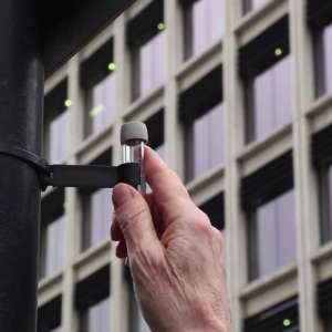
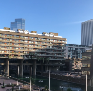
Science in the City
Science in the City is a project that is being carried out with residents in the Barbican and Mansell Street, in the City of London. Residents are using low-tech tools to measure Nitrogen Dioxide and particulates.
Eco21.PL
Funded under the Swiss Block Grant, Mapping for Change in collaboration with the Centre for Training and Personal Development MERITUM, the Cultural Authority City of Gardens and Highways 4 Elements carried out a two year training programme in the Silesia region of Poland.
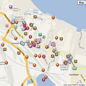
How to Spend a Million? Northfleet Big Local Trust
In 2012, the Big Lottery Fund in England invested £1 million in 150 neighbourhoods for its Big Local initiative. Northfleet, Kent, was one of the first 50 to be selected. The grant aimed to equip local communities with skills and tools to identify key areas and issues where action was reqiored in their area.
Citizen Science Used to Map Community Air Quality
In 2009, Mapping for Change supported communities across London to measure and map local air quality. Use of a ‘citizen science’ approach meant local residents in seven locations were able to collect data, then see the real results of their monitoring activities, and subsequently embark on a campaign to see the serious results addressed.
Putting Ourselves on the Map
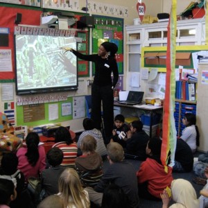
Mapping for Change in collaboration with the Humanities Education Centre (HEC) and local specialist on learning and ‘place’ Maggie Hewitt, worked with three schools in Tower Hamlets (Columbia School Community Map, Arnhem Wharf School Community Map and John Scurr School Community Map) to pilot a brand new process in which Year 4 pupils develop personalised maps of their local area with their own likes, memories and views on change.