Barbican Citizen Science Documentary
On 6th March 2015 Hannah posted in Featured, News
Air pollution levels in UK cities are much worse than many of us realise. London, unsurprisingly, is no exception. Mapping for Change have been working with residents in the Barbican Estate, City of London, to measure air quality levels since October 2013. To celebrate our achievements, we have produced a short documentary about the project processes, and our shocking findings.
Clean Up London Air
On 8th October 2014 Louise posted in Featured, News
Four communities across London took part in a month long citizen science project supported by Mapping for Change. The aim of ‘Clean Up London Air’ was to monitor and map Nitrogen Dioxide (NO2) pollution levels in both quiet residential areas selected by the local residents and adjacent roads with heavy passing traffic during the month of July. The four areas involved in the project, Latimer Road, Camden, Islington and Crystal Palace can be viewed on the Air Quality Community Map.
Science in the City Maps Dust Storm
On 18th June 2014 Louise posted in Events, Featured
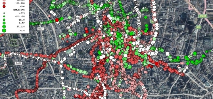
As part of the Science in the City project, residents of the Barbican Estate in the City of London monitored their local air quality between October 2013 and May 2014. Since February, residents have been using handheld sensors to track the presence of PM2.5 particulates* whilst on their everyday journeys and have managed to capture the effects of the dust storm in their community.
Twenty-five Barbican residents took part, carrying the sensors for up to five days each and making eighty-seven journeys in total. Although Science in the City focuses on air quality around the Barbican Estate, residents carried the sensors as far as Darlington and Cambridge providing a wealth of information illustrating changes in air quality across the country as well as in the Barbican area.